Posts Tagged ‘Point Imperial’

Sunrise, Bright Angel Point

Grand Canyon, North Rim, AZ.  As you can see from the image above, it’s just another lovely day in the neighborhood.  From the Grand Lodge, the walk down to Bright Angel Point is only 0.5 mile on a paved path.  For the photographer, the challenge is to arrive at the point before the civilians arrive.  Spots like Bright Angel have a mystical/religious significance for many, and these folks naturally want to stand exactly where you want to set up your kit.  Calculate the time of the sunrise, back the alarm 1.5 hrs, and you are (probably) set.

Warning, even spouses as tolerant as the HP will challenge your sanity at this stratagem.  My advice is to suggest that since it is only a brief stroll, that you can go it solo.  Chances are that by the time you are headed for the door, said spouse will be putting on a jacket, grimly determined to keep their nutty spouse from walking sleepily off the point in search of that perfect capture.


When should you visit the north rim?  This is a question I am often asked.  The easy answer is, ‘When we’re not there’.  Sorry.  The real answer is that the monsoons in southern UT and northern AZ are a real thing, and if you can manage your schedule to dodge them – avoid the last week of July and the first two weeks of August – you are likely to have a more pleasant visit.  Also, remember that the lodge is only open between May 15 and October 15.  Be aware however, that those first and last few weeks are likely to be pretty chilly.

The images for this entry were recorded on August 25, 2010, using the Nikon D3s and the AF-S NIKKOR 24-70mm f/2.8G ED lens.

Copyright 2010 Peter F. Flynn. No usage permitted without prior written consent. All rights reserved.

Afternoon at Point Imperial

Grand Canyon North Rim, AZ. We left SLC headed south along I15 at about 10:15 MDT.  The weather was excellent and the traffic was light.  The route to the from SLC to the North Rim is exactly the same as the route to Zion NP, until you reach the UT Highway 9 junction at La Verkin, at which point you head south to Hurricane, then dodge east along UT Highway 59.

The route continues south into Arizona along Highway 389 through Hilldale and Colorado City, and then eastward along Highway 389 to Fredonia.  BTW, Judd Auto Service in Fredonia has an excellent selection of bottled beer and general supplies.  From Fredonia, continue southeastward along Highway 89a to Jacob Lake.  From Jacob Lake the route turns south, reaching the North Rim in just over 40 miles.

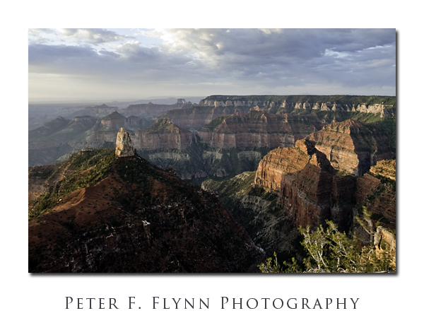
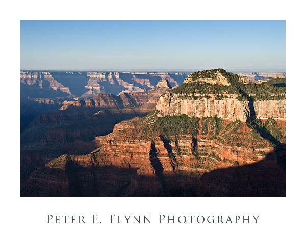
For our first sortie on this visit we decided to pay an afternoon visit to Point Imperial.  This spot is excellent for photography at any time of the day, but for those with a mindset focused on the golden hours, the spot is particular attractive at dawn and the late afternoon.  Note however, that while many spots along the North Rim make excellent locations from which to capture images of the Canyon, the light here often scrams well before the golden hour.  There are several vantage points around the point.  Although the classic vista lies at the end of a short walk down to the precipice, good views; including the one shown here, may be had from the area just below (in front of) the eastern edge of the parking lot.

The image above of Mt. Hayden and was recorded on August 24, 2010, at about 17:30 MDT, using the Nikon D3s and the AF-S 24-70mm f/2.8G ED NIKKOR lens at 44mm.  Exposure was f/8.0 at 1/400s, ISO 200.  The 24-70mm is one of my favorite lenses, super sharp all-around and handles extremely well.

We really enjoy the North Rim.  It’s civilized.  A beautiful high-desert forest that runs off one of the most awesome cliffs on earth.  The place is relatively uncrowded, and since it’s in Arizona, we escape the Utah booze laws (seriously, the Utah politicos really need to stop using liquor laws an an excuse to try to better each other).  No kidding, you can grab a draft beer at The Saloon (it’s actually named The Saloon), in the Grand Lodge complex, and then wander over to the Lodge veranda which overlooks the Transept and Bright Angel Canyon.  A genuine pleasure.

Copyright 2010 Peter F. Flynn. No usage permitted without prior written consent. All rights reserved.
Sunrise at Point Imperial

DSC3357_Framed_Overlay_+_1percent_MFM

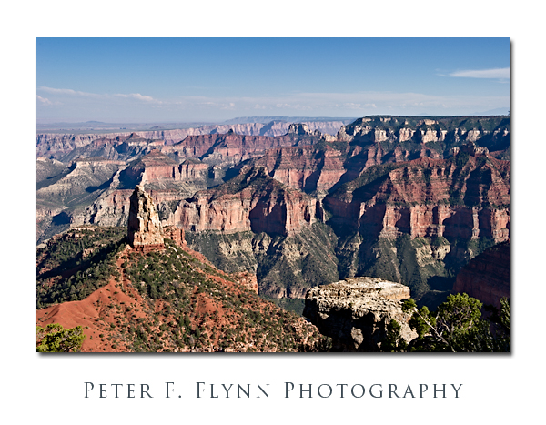
Okay, well, you *do* have to get up a bit early to catch the sunrise at this time of year, but it’s absolutely worth the effort.  How often to you stumble out of bed, throw on some clothes and arrive at work to find this scene waiting?!!!  A beautiful cool dawn at Point Imperial.  It’s just me, the HP, and a couple of young guys who disappeared immediately after the sun had cleared the horizon.  Yeah, this is why we like the north rim of the Grand Canyon – well away from the crushing crowds that are present all along the south rim.

Point Imperial is an easy drive from the North Rim (Bright Angel) Lodge – travel about 3 miles north on AZ 67 to the junction with Fuller Canyon Road.   Turn right, and travel along Fuller Canyon Road (northeast, then southeast) five miles to a second junction with roads that head north(ish) to Point Imperial or south(ish) to Cape Royal.  Travel about three miles northeast along the Point Imperial Road to road ends at the large parking lot above the point.  Point Imperial is about 100 yards down a paved path.

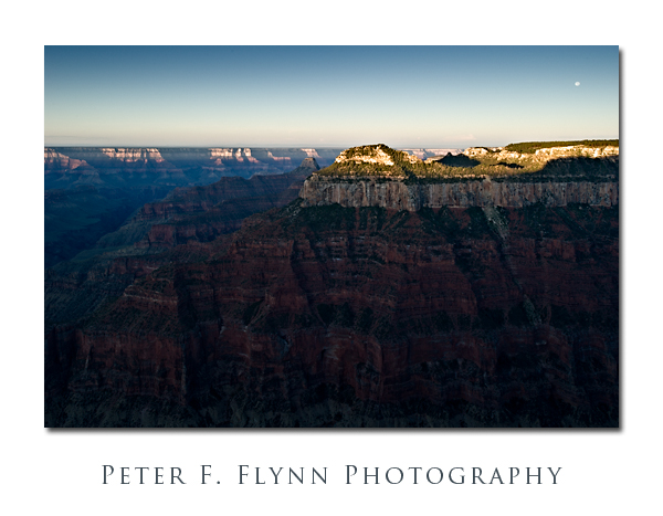
The view is approximately due south, and includes from left to right, the Painted Desert and the south rim, the spire of Mount Hayden, Ehrenberg Point and Novinger and Alsap Buttes, the valley of Nankoweap Creek, Sullivan Peak  (nearer) and Hancock Butte, and Kibbey Butte.

The image above was recorded on July 19, 2009, at 06:48 MST, using the Nikon D700 and the PC-E NIKKOR 24mm f/3.5D ED.  Shift was set at about 11 mm.  Exposure was  f/22 at 1/3s – if you look closely at the greenery in the right foreground you can clearly see a bit of blur – it’s almost always breezy here.  ISO was 200.  The clouds in the image were enhanced by applying an Overlay Move using the red channel.  The Man-from-Mars method was then applied to enhance color and contrast in the canyon walls.  Note that both the Overlay Move and the Man-from-Mars Maneuver were invented by Dan Margulis – guru of pre-press processing and the doyen of LAB color manipulation.  Finally and importantly, the reproduction of this image, like many picture-postcard-like images, is highly monitor dependent – I have deliberately tried to split the difference between low contrast and high contrast systems – admittedly, with limited success.  Curiously, even identical images displayed in Photoshop and in the web browser – yes, of course in the same color space  (sRGB) – may be very different.  As a point of comparison, I include a version (below) of the image that has been more conservatively processed – only the Overlay Move was applied:

Point Imperial Conservative Version

The Nikon GP1 GPS device continues to impress.  The coordinates of the site are given below:

Latitude: 36,16.7365N

Longitude: 111,58.6507W

Altitude: 2692.00 m (8832 ft)

Time Stamp: 7/19/2009, 12:475 PM

Click on the thumbnails below for Google Earth views of the location:

Point Imperial Google Earth Image Closer

Point Imperial Google Earth Image