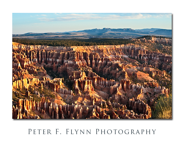
You will immediately recognize that the image above was shot at or near Bryce Canyon National Park, since there isn’t anything like these particular Hoodoo and fin formations anywhere else on the planet (okay, at Cedar Breaks National Monument as well, but that is part of the same geological structure). Bryce Canyon is actually more a cliff than a canyon, and it forms the upper tread in the series of steps that forms the Grand Staircase, leading down through the Pink and Grey Cliffs, through the White Cliffs and Zion NP, across the Sevier Fault to the Vermilion Cliffs, and ending finally, at the Grand Canyon NP. In geological terms, Bryce Canyon is an escarpment of the Paunsaugunt Plateau. The escarpment exposes the limestone, shale, and sandstone components of the Claron Formation.
If you’ve been to the park, or read anything at all about it, you probably know that it is named after Ebenezer Bryce, a Scottish immigrant and LDS pioneer. The Bryce family lived in the nearby Paria River valley for a short time, during which time the place became known as Bryce’s Canyon. The family soon moved on to (Bryce) Arizona, but the canyon kept its name. An often-recited quote due to Bryce, that the canyon is ‘One Hell of a place to loose a cow’, sums up a practical pioneer’s view of the beautiful but maze-like qualities of the place. Perhaps Ebenezer was a student of the classics, since according to Greek mythology, Daedalus built a labyrinth for King Minos in order to contain the Minotaur, the half-bull/half-human scourge of the Greeks.
Bryce Canyon is about 15 miles southeast of Panguich, UT, on UT63, which runs south of the junction from UT12. There are accommodations in Panguich, and a bit closer at the Ruby’s Inn Megaplex, however I prefer to stay at the Lodge inside of the park, as this makes it a little easier to get into position for the sunrise shoot. For those of you who may be visiting other parks in the area, Bryce Canyon NP is between Zion NP (along UT9 and US89) to the southwest, and Capitol Reef NP to the northeast (along UT12) – both within striking range if you are keen for a brief visit.
The image above was recorded on September 12, 2009 at about 07:30 MST using the Nikon D700 and the AF-S VR Zoom-NIKKOR 70-300mm f/4.5-5.6G IF-ED lens at 70mm. Exposure was f/16 at 1/15s, ISO 200. Processing included blending of the green channel into the red channel to improve contrast, followed by curves adjustments on the (new) red and green channels.
Of course there are many excellent opportunities to indulge your photographic exploits here, and in my opinion the best of the points along the rim are, from north to south: Sunrise and Sunset points, Bryce Point, and Rainbow Point. Be warned that these spots can be extremely crowded – and I mean Grand-Canyon-south-rim type of crowded. During high season for example, at dawn, there may be over 100 photographers lining the area around Sunrise Point – and believe it or not over half of them have tripods set up, legs literally intertwined. If you want a good spot, you need to be on site not less than one hour before sunrise or sunset.
Copyright 2010 Peter F. Flynn. No usage permitted without prior written consent. All rights reserved.
