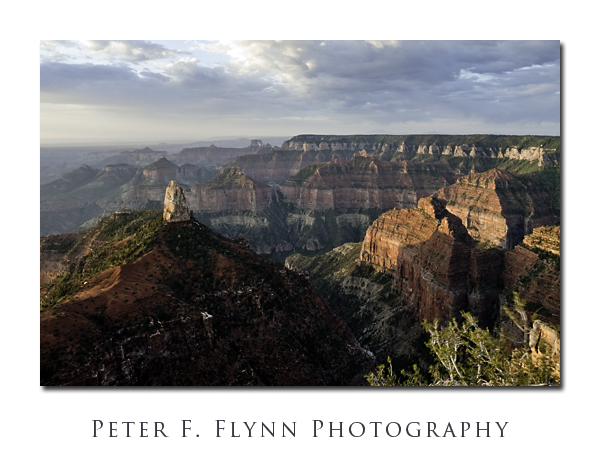
Okay, well, you *do* have to get up a bit early to catch the sunrise at this time of year, but it’s absolutely worth the effort. How often to you stumble out of bed, throw on some clothes and arrive at work to find this scene waiting?!!! A beautiful cool dawn at Point Imperial. It’s just me, the HP, and a couple of young guys who disappeared immediately after the sun had cleared the horizon. Yeah, this is why we like the north rim of the Grand Canyon – well away from the crushing crowds that are present all along the south rim.
Point Imperial is an easy drive from the North Rim (Bright Angel) Lodge – travel about 3 miles north on AZ 67 to the junction with Fuller Canyon Road. Turn right, and travel along Fuller Canyon Road (northeast, then southeast) five miles to a second junction with roads that head north(ish) to Point Imperial or south(ish) to Cape Royal. Travel about three miles northeast along the Point Imperial Road to road ends at the large parking lot above the point. Point Imperial is about 100 yards down a paved path.
The view is approximately due south, and includes from left to right, the Painted Desert and the south rim, the spire of Mount Hayden, Ehrenberg Point and Novinger and Alsap Buttes, the valley of Nankoweap Creek, Sullivan Peak (nearer) and Hancock Butte, and Kibbey Butte.
The image above was recorded on July 19, 2009, at 06:48 MST, using the Nikon D700 and the PC-E NIKKOR 24mm f/3.5D ED. Shift was set at about 11 mm. Exposure was f/22 at 1/3s – if you look closely at the greenery in the right foreground you can clearly see a bit of blur – it’s almost always breezy here. ISO was 200. The clouds in the image were enhanced by applying an Overlay Move using the red channel. The Man-from-Mars method was then applied to enhance color and contrast in the canyon walls. Note that both the Overlay Move and the Man-from-Mars Maneuver were invented by Dan Margulis – guru of pre-press processing and the doyen of LAB color manipulation. Finally and importantly, the reproduction of this image, like many picture-postcard-like images, is highly monitor dependent – I have deliberately tried to split the difference between low contrast and high contrast systems – admittedly, with limited success. Curiously, even identical images displayed in Photoshop and in the web browser – yes, of course in the same color space (sRGB) – may be very different. As a point of comparison, I include a version (below) of the image that has been more conservatively processed – only the Overlay Move was applied:
The Nikon GP1 GPS device continues to impress. The coordinates of the site are given below:
Latitude: 36,16.7365N
Longitude: 111,58.6507W
Altitude: 2692.00 m (8832 ft)
Time Stamp: 7/19/2009, 12:475 PM
Click on the thumbnails below for Google Earth views of the location:
Tags: Bright Angel Lodge, Fuller Canyon Road, Grand Canyon, Mount Hayden, Mt. Hayden, North Rim, North Rim Lodgr, Point Imperial


Great image. Ansel Adams once said something along the lines of “a photographer should hope to accumulate 12 images a year of high quality”. The one above is clearly one of your 12, a great shot. I love the clouds.
Hi B,
Thanks for the comment! Yeah, it’s definitely one of those places you can work with… The semi-monsoonal weather pattern did have it’s good points after all!
Cheers,
P.