Archive for the ‘National Parks and Monuments’ Category

The Bentonite Hills

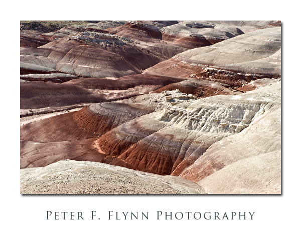
Capitol Reef National Park, UT. Given the vast area, it is simply not possible to photograph the entirety of the Cathedral Valley in favorable light in a single day.  Yes, I know, I said that you don’t always need the light of the golden hour to render compelling images, but there are practical limitations.  I believe that Cathedral Valley can be well-covered in two days, provided that weather and road conditions cooperate.  As I have observed in a previous entry, I believe that the preferred route starts at Caineville, at the opposite end of the ‘standard’ loop, which provides a formula for obtaining images of the lower Cathedral Valley or the western sections of the upper Cathedral Valley.  The significant missing element of this strategy is the opportunity to create morning-light images of the southeastern sector of the Cathedral Valley, and most notably, The Bentonite Hills along the Hartnet Road.

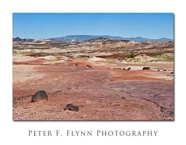
According to the Park geology website, the Bentonite Hills are part of the Brushy Basin shale member of the Morrison Formation, laid down in the Jurassic Period, from 156 to 147 million years ago.  The formation is characterized by low-lying smoothly-contoured hills, with bands of color that may include blues, greens, reds, and violets.  Bentonite is a silicate clay formed from volcanic ash that may include aluminum, calcium, potassium, and/or sodium.  Close up, the surface is rough and broken in what some has characterized as a popcorn-like appearance.  If there was ever an expanse that deserved the name ‘badlands’, The Benonite Hills is it.  Hardly a thing grows anywhere, not even exploratory shoots.

The Hills are most easily reached from the ‘standard’ route around Cathedral Valley, starting from the Fremont River ford.  The Fremont is a modest stream under normal conditions, and is usually easily crossed.  The road winds upward in to The Bentonite Hills, gaining perhaps a few hundred feet in a half-mile, entering the lower Cathedral Valley.  The Hills are about nine mile west of the river crossing, along a gravel road that can be traveled in all but the most inclement conditions.  The road leads pretty much straight though the middle of the formation, so that compelling images can be made looking north/south-eastward (morning) or north/south-westward (late afternoon).

Note that bentonite readily absorbs water (up to many times its own dry weight), and consequently the material becomes impossibly sticky when wet.  Thus, travel through The Bentonite Hills should not be attempted during or shortly after significant rain.

The images above were recorded at around 09:00 MDT on July 25, 2010, using the Nikon D3s and the AF-S NIKKOR 24-70mm f/2.8G ED lens at various focal lengths.  The 24-70mm it is remarkably sharp at all focal lengths.  A major critique is that it lacks VR – but I do not believe that this is a serious shortcoming.  I find this range, 24mm-70m, to be very serviceable in the field.

Copyright 2010 Peter F. Flynn. No usage permitted without prior written consent. All rights reserved.
Pectol’s Pyramid

Ephraim Pectol was a Torrey storekeeper with a vision to introduce the Capitol Reef area to the world.  Together with his brother-in-law, Joseph Hickman, a local educator, Pectol organized efforts in the 1920’s to advertise the Wayne County wonderland to Americans and adventurous Europeans.  Their success is readily verified by the popularity of the park.

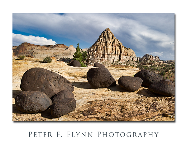
The shape of the ‘pyramid’ changes significantly depending on the perspective of the viewer.  Geologically, the pyramid is unique in its angled form – Navajo Sandstone formations typically acquire a smooth or rounded appearance.  Curiously, this sandstone monolith acquires its eponymous form only when viewed from the ridge across the Fremont River.  The Navajo Knobs trail departs from the Hickman Bridge Trail after about 1 mile, and heads northwest, mounting the ridge.  Walking westward along the trail brings the pyramidal shape into view, and provides opportunities for making a compelling image.

The strata here was laid down during the Permian through Cretaceous eras, about 270-80 million years ago. The dark basalt rocks that litter the Navajo Sandstone ridge are much younger, at 20-30 million years old.  These newcomers provide an important contrast element to the Navajo Sandstone in the foreground.

The image above was recorded at 17:30 MDT on July 23, 2010, using the Nikon D3s and the AF-S NIKKOR 24-70mm f/2.8G ED lens at 34mm.  Exposure was f/16.0 and 1/60s, EV +1, ISO 200.  The best captures will be made in the late afternoon and later, when the main light falls at an acute angle from the west.

Copyright 2010 Peter F. Flynn. No usage permitted without prior written consent. All rights reserved.
Strike Valley Overlook

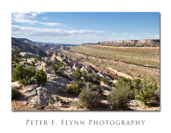
One of the highlights to a visit to Capitol Reef National Park is a drive south along the Notom-Bullfrog Road (NBR).  The NBR heads south-southeast from the junction with Utah Highway 24 (about 9 miles east of the Visitors Center), and slips along the margin between the Waterpocket Fold and Strike Valley.  At about 34 miles from the junction of the NBR and UT24, you reach a junction that heads westward up the Burr Trail Switchbacks.  A short drive west from top of the switchbacks brings you to the Upper Muley Twist Road that heads north along the Waterpocket Fold.  From the end of the road a short hike eastward brings you to a world-class perch, the famous Strike Valley Overlook – seriously, I’ve walked all over the west, this may be THE place.

To be precise, a ‘strike valley’ is a common geological formation found most anywhere immediately adjacent to a significant fold or upheaval.  What we are talking about in this entry however is among the best examples found anywhere.  This strike valley runs along the southern portion of the Fold from Cedar Mesa Camp about 11 miles south of UT 24 to the southern margin of the Park.  The overlook grants views of the Strike Valley north and south along the Waterpocket Fold, and east to the Henry Mountains.

The image above was recorded at 18:00 MDT on July 24, 2010, using the Nikon D3s and the NIKKOR AF-S 24-70mm f/2.8G ED lens at 42mm.  Exposure was f/16 and 1/200s (+0.33EV), ISO 400.  Coordinates of the site are 37,52.9900N/111.2.5372W.

The overlook may also be reached from the west, by traveling east 26 miles out of Boulder, UT.  The Burr Trail Road is paved from Boulder to about 5 miles before the switchbacks.  On this visit we executed a loop trip back along this route to Boulder, and then north to Torrey, UT, along the magic UT Highway 12.

A few important suggestions.  It would be an excellent idea to stop by the Visitors Center and chat with the staff about road conditions.  Be aware that Park Staff are programmed to speak from a ‘better safe than sorry’ perspective, however this truly is a remote region with no water, and challenging driving conditions.  The NBR is paved for the first 5 miles south from the junction with UT24, and then converts into dusty washboard south of that point.  As is true most everywhere in south-central UT, roads in wet to very wet conditions are impassable, as in if you attempt to move you will slide off of the road, or become stuck in thick mud.  The Burr Trail switchbacks are steep, but perfectly safe in dry conditions – they might be a bit of  thrill for those with little backcountry driving experience.  The Upper Muley Twist Road cannot be safely navigated by a low-clearance vehicles, although 4WD is probably only necessary in wet conditions.  I also predict that very large pickups and wide vehicles (think Hummers) will have to execute some tricky moves to make it to road’s end (we drove a Toyota Tacoma with the crew-cab and associated short-bed).

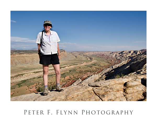
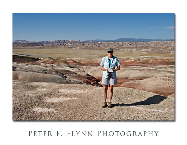
Finally (below), a shot of The HP, and the southern view into the Strike Valley.  The image was recorded using the D3s and the 24-70mm lens at 32mm.  Exposure was f/16 and 1/400s, ISO at 400.  Handheld.  You could not deduce it from her calm and relaxed appearance in the image, but the HP was the most awesome support ever – carrying a 20lb camera bag and tripod while chasing a panicky photog back and forth along a 200 meter section of the Fold in the failing light.

Copyright 2010 Peter F. Flynn. No usage permitted without prior written consent. All rights reserved.